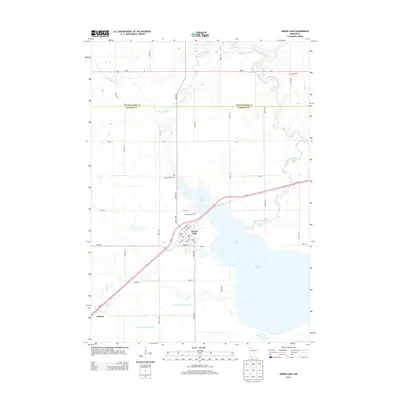
2013 Map of Heron Lake
USGS Topo · Published 2013About this map
Heron Lake and its surrounding wetlands dominate the landscape of Jackson and Cottonwood counties in this 2013 survey. The city of Heron Lake serves as a central hub, situated near the shores of Duck Lake and the Heron Lake Outlet, while the small settlement of Miloma marks the southwestern portion of the sheet. The region's agricultural and drainage history is evident through the inclusion of the Des Moines River and artificial waterworks like Judicial Ditch Number Two. Local genealogy is well-supported by several distinct burial sites including Lakeside Cem, Sacred Heart Cem, and Springfield Cem. The map provides a detailed view of the local infrastructure, tracing the paths of MN-60 and MN-62 alongside older routes like Old Hwy 60 and Chapman Ave. Smaller watercourses like Jack Cr and Division Creek illustrate the natural hydrology of this prairie lake region.
Find a feature on this map
34 named features on this map. Tap any name to fly to it.
Don’t see what you’re looking for? This feature index may not catch every label — zoom into the map to look around manually.
Map Details
Editions of this 2013 Heron Lake Map
This is the sole edition of this map. No revisions or reprints were ever made.
Other maps of this area

1954 · Fairmont
USGS Topo · 1:250,000

1958 · Fairmont
USGS Topo · 1:250,000

1960 · Brewster
USGS Topo · 1:24,000

1960 · Okabena
USGS Topo · 1:24,000

1970 · Heron Lake NW
USGS Topo · 1:24,000
1970 · Harder Lake
USGS Topo · 1:24,000

1970 · Dundee
USGS Topo · 1:24,000

1970 · Wilder
USGS Topo · 1:24,000

1970 · Lakefield
USGS Topo · 1:24,000
1970 · Heron Lake NE
USGS Topo · 1:24,000