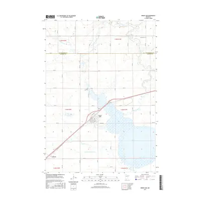
2016 Map of Heron Lake
USGS Topo · Published 2016About this map
Heron Lake sits as the central geographic feature of this southwestern Minnesota prairie landscape, surrounded by a complex network of waterways including the Des Moines River and the Heron Lake Outlet. The settlement of Heron Lake is organized around a traditional grid featuring Chapman Ave and numbered streets like 11th St and 12th St. To the southwest, the junction at Miloma reflects the region's historic transportation patterns where rail and road corridors intersect near the banks of Jack Cr.
Find a feature on this map
53 named features on this map. Tap any name to fly to it.
Don’t see what you’re looking for? This feature index may not catch every label — zoom into the map to look around manually.
Map Details
Editions of this 2016 Heron Lake Map
This is the sole edition of this map. No revisions or reprints were ever made.
Other maps of this area

1954 · Fairmont
USGS Topo · 1:250,000

1958 · Fairmont
USGS Topo · 1:250,000

1960 · Brewster
USGS Topo · 1:24,000

1960 · Okabena
USGS Topo · 1:24,000

1970 · Heron Lake NW
USGS Topo · 1:24,000
1970 · Harder Lake
USGS Topo · 1:24,000

1970 · Dundee
USGS Topo · 1:24,000

1970 · Wilder
USGS Topo · 1:24,000

1970 · Lakefield
USGS Topo · 1:24,000
1970 · Heron Lake NE
USGS Topo · 1:24,000