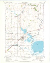
1970 Map of Heron Lake
USGS Topo · Published 1972About this map
The Heron Lake shoreline and the surrounding agricultural basin of Weimer and La Crosse are captured here in the early 1970s. This survey illustrates a vital rail junction at Heron Lake, where the Chicago and North Western tracks intersect, while the Chicago Milwaukee St Paul and Pacific line skirts the southern edge through the small settlement of Miloma. The landscape is defined by its water management and conservation efforts, seen in the Judicial Ditch No 2 and the Crosse State Wildlife Management Area. Local landmarks like the Héron Lake Memorial Field, several community burial grounds including Lakeside Cem, and the Des Moines River meandering through Southbrook provide a detailed look at the rural infrastructure and natural features of Jackson County during this period.
Find a feature on this map
27 named features on this map. Tap any name to fly to it.
Don’t see what you’re looking for? This feature index may not catch every label — zoom into the map to look around manually.
Map Details
Editions of this 1970 Heron Lake Map
This is the sole edition of this map. No revisions or reprints were ever made.
Other maps of this area

1954 · Fairmont
USGS Topo · 1:250,000

1958 · Fairmont
USGS Topo · 1:250,000

1960 · Brewster
USGS Topo · 1:24,000

1960 · Okabena
USGS Topo · 1:24,000

1970 · Heron Lake NW
USGS Topo · 1:24,000
1970 · Harder Lake
USGS Topo · 1:24,000

1970 · Dundee
USGS Topo · 1:24,000

1970 · Wilder
USGS Topo · 1:24,000

1970 · Lakefield
USGS Topo · 1:24,000
1970 · Heron Lake NE
USGS Topo · 1:24,000