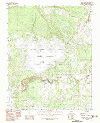
1983 Map of Heron Reservoir
USGS Topo · Published 1983About this map
The Tierra Amarilla Grant boundary defines the landscape of this northern New Mexico territory, where the waters of the Rio Chama flow through complex terrain toward the El Vado Reservoir. This 1983 provisional survey shows the established footprint of the Heron Reservoir, a central feature of the Heron Lake State Park. The map documents the localized topography around The Peninsula and The Narrows, illustrating how the man-made lake adapted to the existing canyons and drainages such as Willow Creek and Cañada de la.
Find a feature on this map
14 named features on this map. Tap any name to fly to it.
Don’t see what you’re looking for? This feature index may not catch every label — zoom into the map to look around manually.
Map Details
Editions of this 1983 Heron Reservoir Map
2 editions found
Other maps of this area

1954 · Aztec
USGS Topo · 1:250,000

1955 · Chama
USGS Topo · 1:62,500

1955 · Lumberton
USGS Topo · 1:62,500

1955 · Tierra Amarilla
USGS Topo · 1:62,500

1955 · Boulder Lake
USGS Topo · 1:62,500

1958 · Aztec
USGS Topo · 1:250,000

1962 · Aztec
USGS Topo · 1:250,000

1965 · Aztec
USGS Topo · 1:250,000

1981 · Chama
USGS Topo · 1:100,000
1983 · Pounds Mesa
USGS Topo · 1:24,000