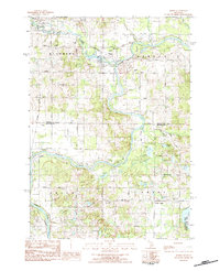
1983 Map of Hersey
USGS Topo · Published 1984About this map
The confluence of the Muskegon River and Hersey River forms the geographic heart of this Osceola County region in the early 1980s. The village of Hersey sits at this river junction, which historically served as a vital hub for Michigan's logging industry. The surrounding landscape is characterized by a dense network of country roads following the section lines, including Three Mile Road and Meceola Road, which bridge the boundary between Osceola and Mecosta counties. Genealogists can find several established burial grounds, such as Oakdale Cem and Bittner Cem, which speak to the area's 19th-century settlement. The Chesapeake and Ohio railroad line cuts through the northern half of the map, servicing Reed City and the industrial gravel pits that punctuate the river valley. To the southeast, the terrain shifts toward the managed wetlands of the Haymarsh Lake State Game Area.
Find a feature on this map
51 named features on this map. Tap any name to fly to it.
Don’t see what you’re looking for? This feature index may not catch every label — zoom into the map to look around manually.
Map Details
Editions of this 1983 Hersey Map
This is the sole edition of this map. No revisions or reprints were ever made.
Other maps of this area

1931 · Chase NE
USGS Topo · 1:31,680

1954 · Midland
USGS Topo · 1:250,000

1958 · Midland
USGS Topo · 1:250,000

1958 · Woodville
USGS Topo · 1:62,500

1958 · Big Rapids
USGS Topo · 1:62,500

1959 · Midland
USGS Topo · 1:250,000

1959 · Evart
USGS Topo · 1:62,500

1959 · Reed City
USGS Topo · 1:62,500

1966 · Midland
USGS Topo · 1:250,000

1976 · Evart SW
USGS Topo · 1:24,000