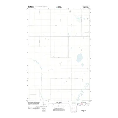
2011 Map of Hesper
USGS Topo · Published 2011About this map
The settlement of Hesper is the primary community on this Benson County sheet, characterized by a grid of agricultural section roads and the winding path of the North Fork Sheyenne River. This drainage system eventually meets the main channel of the Sheyenne River in the southeast corner. The prairie landscape is dotted with prominent local water bodies, including Legreid Lake, Lake Mary, and Lake Seventeen. These basins represent the classic pothole geology of the North Dakota plains. Near the northern edge of the township, the Hesper Cemetery serves as a significant genealogical landmark for the surrounding rural area. The map illustrates a highly organized rural infrastructure, where named routes like 40th Ave NE and 33rd St NE define the boundaries of large farming plots, showing how the landscape was systematically divided to support the region's agricultural economy.
Find a feature on this map
21 named features on this map. Tap any name to fly to it.
Don’t see what you’re looking for? This feature index may not catch every label — zoom into the map to look around manually.
Map Details
Editions of this 2011 Hesper Map
This is the sole edition of this map. No revisions or reprints were ever made.
Other maps of this area

1941 · Selz
USGS Topo · 1:62,500

1943 · Maddock
USGS Topo · 1:62,500

1945 · Maddock
USGS Topo · 1:62,500

1950 · Wellsburg
USGS Topo · 1:24,000

1951 · Selz NE
USGS Topo · 1:24,000

1951 · Maddock
USGS Topo · 1:24,000
1951 · Heimdal
USGS Topo · 1:24,000

1951 · Hesper
USGS Topo · 1:24,000
1951 · Hamberg
USGS Topo · 1:24,000

1952 · New Rockford
USGS Topo · 1:250,000