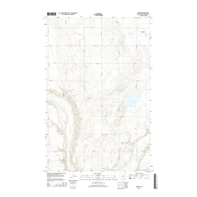
2014 Map of Hesper
USGS Topo · Published 2014About this map
Hesper and its surrounding prairie landscape define this Benson County quadrangle, where the N Fork Sheyenne River carves a distinct valley through the undulating plains. The settlement itself is anchored by the Hesper Cem to the north, reflecting the long-term community history of this North Dakota region. Water is a central element of the terrain, from the larger expanse of Legreid Lake to smaller basins like Lake Seventeen and Lake Mary. This 2014 survey captures the precise grid of section roads, including 44th Ave NE and 32nd St NE, which facilitate the agricultural life of the area. Significant hydrologic features such as the Sheyenne River and Palmer Spring indicate the essential drainage patterns that have shaped land use and local geography for generations.
Find a feature on this map
23 named features on this map. Tap any name to fly to it.
Don’t see what you’re looking for? This feature index may not catch every label — zoom into the map to look around manually.
Map Details
Editions of this 2014 Hesper Map
This is the sole edition of this map. No revisions or reprints were ever made.
Other maps of this area

1941 · Selz
USGS Topo · 1:62,500

1943 · Maddock
USGS Topo · 1:62,500

1945 · Maddock
USGS Topo · 1:62,500

1950 · Wellsburg
USGS Topo · 1:24,000

1951 · Selz NE
USGS Topo · 1:24,000

1951 · Maddock
USGS Topo · 1:24,000
1951 · Heimdal
USGS Topo · 1:24,000

1951 · Hesper
USGS Topo · 1:24,000
1951 · Hamberg
USGS Topo · 1:24,000

1952 · New Rockford
USGS Topo · 1:250,000