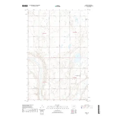
2018 Map of Hesper
USGS Topo · Published 2018About this map
Hesper serves as the primary landmark in this section of Benson County, situated in a prairie landscape defined by glacial depressions and seasonal water bodies. The terrain is notably characterized by its numerous natural basins, including Lake Seventeen, Lake Mary, and Legreid Lake, which dot the northern and central townships. For those researching local heritage, the Hesper Cem and the Fairview Scandinavian Lutheran Cem offer specific points of interest tied to the area's early settlement by European immigrants. The hydrological network is dominated by the Sheyenne River and its northern branch, the N Fork Sheyenne River, which meander through the southern half of the quadrangle. The agricultural grid is well-defined by local routes such as Oksendahl Rd and Green Rd, while Palmer Spring provides a rare named groundwater feature in this high-plains environment.
Find a feature on this map
32 named features on this map. Tap any name to fly to it.
Don’t see what you’re looking for? This feature index may not catch every label — zoom into the map to look around manually.
Map Details
Editions of this 2018 Hesper Map
This is the sole edition of this map. No revisions or reprints were ever made.
Other maps of this area

1941 · Selz
USGS Topo · 1:62,500

1943 · Maddock
USGS Topo · 1:62,500

1945 · Maddock
USGS Topo · 1:62,500

1950 · Wellsburg
USGS Topo · 1:24,000

1951 · Selz NE
USGS Topo · 1:24,000

1951 · Maddock
USGS Topo · 1:24,000
1951 · Heimdal
USGS Topo · 1:24,000

1951 · Hesper
USGS Topo · 1:24,000
1951 · Hamberg
USGS Topo · 1:24,000

1952 · New Rockford
USGS Topo · 1:250,000