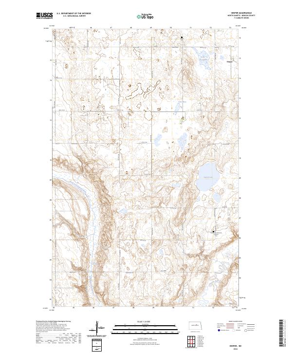
2024 Map of Hesper
USGS Topo · Published 2024About this map
The North Fork Sheyenne River meanders across this Benson County landscape, shaping a terrain defined by glacial prairie potholes and managed wetlands. The settlement of Hesper serves as a local anchor in the northeast, near the Hesper Cem and the waters of Lake Seventeen. This contemporary survey highlights the region's commitment to conservation, with several segments of the Benson County Waterfowl Production Area preserved throughout the township lines, including lands surrounding Legreid Lake. Genealogists will find interest in the Fairview Scandinavian Lutheran Cem located in the southeastern quadrant, reflecting the Scandinavian heritage of the settlers who established these plains farms. The map traces a grid of section-line roads such as Oksendahl Rd and Green Rd, which connect remote prairie reaches and water features like Lake Mary and Palmer Spring.
Find a feature on this map
29 named features on this map. Tap any name to fly to it.
Don’t see what you’re looking for? This feature index may not catch every label — zoom into the map to look around manually.
Map Details
Editions of this 2024 Hesper Map
This is the sole edition of this map. No revisions or reprints were ever made.
Other maps of this area

1941 · Selz
USGS Topo · 1:62,500

1943 · Maddock
USGS Topo · 1:62,500

1945 · Maddock
USGS Topo · 1:62,500

1950 · Wellsburg
USGS Topo · 1:24,000

1951 · Selz NE
USGS Topo · 1:24,000

1951 · Maddock
USGS Topo · 1:24,000
1951 · Heimdal
USGS Topo · 1:24,000

1951 · Hesper
USGS Topo · 1:24,000
1951 · Hamberg
USGS Topo · 1:24,000

1952 · New Rockford
USGS Topo · 1:250,000