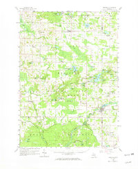
1958 Map of Hesperia
USGS Topo · Published 1969About this map
Hesperia and Walkerville serve as primary hubs within a landscape defined by the dense woodlands of the Manistee National Forest and an intricate network of glacial lakes. In the late 1950s, this region of western Michigan maintained a traditional rural infrastructure, evidenced by numerous small schoolhouses like Volney Sch and Rathburn Sch situated at local crossroads. The presence of the Indian Cem near Island Lake and St Josephs Ch to the west reflects the deep community and cultural roots established long before the mid-century. Industry is represented by localized Gravel Pits and an active Oil Field in the northern reaches, while recreational landmarks such as Camp Manistee and Camp Keewana highlight the area's transition into a destination for outdoor retreat. The map meticulously documents these small-scale features, from the Town Hall in Ferry to the remote Carpenter Cem near Leavitt Lake.
Find a feature on this map
103 named features on this map. Tap any name to fly to it.
Don’t see what you’re looking for? This feature index may not catch every label — zoom into the map to look around manually.
Map Details
Editions of this 1958 Hesperia Map
3 editions found

Other maps of this area

1929 · Montague
USGS Topo · 1:48,000

1931 · Custer SW
USGS Topo · 1:31,680

1931 · Hart SE
USGS Topo · 1:31,680

1931 · Walkerville NE
USGS Topo · 1:31,680

1931 · Hart NE
USGS Topo · 1:31,680

1931 · Walkerville SW
USGS Topo · 1:31,680

1931 · Walkerville NW
USGS Topo · 1:31,680

1931 · Custer SE
USGS Topo · 1:31,680

1931 · Walkerville SE
USGS Topo · 1:31,680

1932 · Ludington SE
USGS Topo · 1:31,680