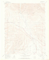
1963 Map of Hesperus
USGS Topo · Published 1973About this map
The La Plata Mountains rise sharply in this early 1960s study, where the La Plata River carves a path through the San Juan National Forest. The landscape is heavily marked by Colorado's mining legacy, showing the concentration of extraction points along the river valley near Mayday and Hesperus. Numerous workings such as the Texas Chief Mine, Bay City Mine, and several coal operations like the Coal King Mine illustrate the transition from precious metal prospecting to fuel resources.
Find a feature on this map
51 named features on this map. Tap any name to fly to it.
Don’t see what you’re looking for? This feature index may not catch every label — zoom into the map to look around manually.
Map Details
Editions of this 1963 Hesperus Map
4 editions found

Other maps of this area

1895 · La Plata
USGS Topo · 1:62,500

1897 · La Plata
USGS Topo · 1:62,500

1898 · Durango
USGS Topo · 1:62,500

1899 · La Plata
USGS Topo · 1:62,500

1907 · Durango
USGS Topo · 1:62,500

1908 · Ignacio
USGS Topo · 1:125,000

1908 · Durango
USGS Topo · 1:62,500

1908 · La Plata
USGS Topo · 1:62,500

1913 · Red Mesa
USGS Topo · 1:62,500

1924 · Ignacio
USGS Topo · 1:125,000