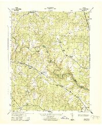
1943 Map of Hewlett
USGS Topo · Published 1943About this map
The North Anna River defines the border between Caroline and Hanover counties during the early 1940s, a period when this rural landscape relied heavily on its rail corridors and river crossings. The Chesapeake and Ohio railroad cuts a diagonal path through the terrain, serving small rural stations and communities like Hewlett, Noel, and North Anna. This era's economic life is visible in the presence of local industry and infrastructure, from the Sawmill at Cedar Fork to the Ottley Mill on the Little River. Social life centered on institutions such as the Mt Hewlett School and Mt Salem Church, while the network of unpaved roads connected specialized agricultural hubs like Chilesburg and Houstons Corner. Important river crossings including Butlers Bridge and Landora Bridge provided the necessary links for local commerce before modern highway development reshaped the region.
Find a feature on this map
26 named features on this map. Tap any name to fly to it.
Don’t see what you’re looking for? This feature index may not catch every label — zoom into the map to look around manually.
Map Details
Editions of this 1943 Hewlett Map
2 editions found
Other maps of this area

1887 · Spottsylvania
USGS Topo · 1:125,000

1889 · Fredericksburg
USGS Topo · 1:125,000

1890 · Goochland
USGS Topo · 1:125,000

1892 · Fredericksburg
USGS Topo · 1:125,000

1892 · Spottsylvania
USGS Topo · 1:125,000

1892 · Goochland
USGS Topo · 1:125,000

1894 · Fredericksburg
USGS Topo · 1:125,000

1918 · Doswell
USGS Topo · 1:62,500

1942 · Woodford
USGS Topo · 1:31,680
1942 · Ladysmith
USGS Topo · 1:31,680