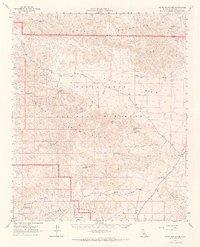
1963 Map of Hexie Mountains
USGS Topo · Published 1969About this map
Joshua Tree National Monument dominates this mid-century survey, revealing a landscape defined by desert mining operations and ephemeral water sources. Prospecting history is etched across the Hexie Mountains and Pinto Mountains, where remote sites like the Old Swede Mine, Golden Bee Mine, and Snow Cloud Mine suggest the region's mineral-driven activity.
Find a feature on this map
34 named features on this map. Tap any name to fly to it.
Don’t see what you’re looking for? This feature index may not catch every label — zoom into the map to look around manually.
Map Details
Editions of this 1963 Hexie Mountains Map
3 editions found
Other maps of this area

1904 · Indio
USGS Topo · 1:125,000

1940 · Cottonwood Spring
USGS Topo · 1:62,500

1940 · Canyon Spring
USGS Topo · 1:62,500

1941 · Coachella
USGS Topo · 1:62,500

1942 · Amboy
USGS Topo · 1:250,000

1943 · Amboy
USGS Topo · 1:250,000

1943 · Canyon Spring
USGS Topo · 1:62,500

1943 · Coachella
USGS Topo · 1:62,500

1943 · Pinkham Well
USGS Topo · 1:62,500

1944 · Cottonwood Spring
USGS Topo · 1:62,500