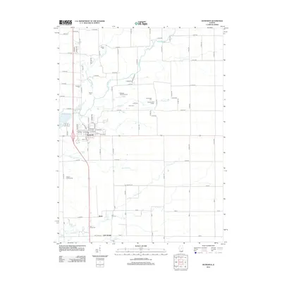
2012 Map of Heyworth
USGS Topo · Published 2012About this map
Heyworth serves as the central hub of this McLean County landscape, where the local street grid intersects with regional transit corridors. The village is surrounded by a dense network of burial grounds that offer significant genealogical value, including Heyworth Cem, Saint Patricks Cem, and the Old Rutledge Cem. This distribution of cemeteries, many associated with early family names or vanished congregations like Shiloh Cem and Passwater Cem, indicates a long-settled agricultural community. The terrain is defined by a series of southwest-flowing waterways, most notably Kickapoo Cr and Long Point Cr, which carve through the prairie. While the economy remains deeply rooted in the soil, specialized aviation markers such as Lytleville Orchard Airport and the Quinton Landing Strip reflect modern land use in this rural Illinois corridor between Bloomington and Clinton.
Find a feature on this map
83 named features on this map. Tap any name to fly to it.
Don’t see what you’re looking for? This feature index may not catch every label — zoom into the map to look around manually.
Map Details
Editions of this 2012 Heyworth Map
This is the sole edition of this map. No revisions or reprints were ever made.
Other maps of this area

1949 · Mc Lean
USGS Topo · 1:62,500

1951 · McLean
USGS Topo · 1:62,500

1951 · Le Roy
USGS Topo · 1:62,500

1957 · Kenney
USGS Topo · 1:62,500

1957 · Maroa
USGS Topo · 1:62,500

1958 · Peoria
USGS Topo · 1:250,000

1961 · Peoria
USGS Topo · 1:250,000

1963 · Peoria
USGS Topo · 1:250,000

1979 · De Witt
USGS Topo · 1:24,000
1979 · Clinton
USGS Topo · 1:24,000