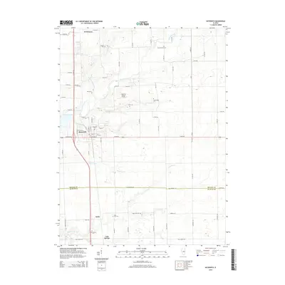
2015 Map of Heyworth
USGS Topo · Published 2015About this map
Heyworth serves as the central hub of this Central Illinois landscape, situated at the intersection of a grid-iron road network and several winding watercourses. The town's local history is anchored by Heyworth Cem and the residential streets surrounding E Main St. This 2015 survey reveals a high density of rural burial grounds that speak to generations of local farming families, including Diamond Grove Cem, Old Rutledge Cem, and Passwater Cem. The terrain is defined by the drainage patterns of Kickapoo Creek and its tributaries, such as Little Kickapoo Creek and Burlison Cr, which cut through the agricultural sections. To the south, the settlements of Bucks and Carle Springs sit near the border of McLean Co and De Witt Co, while the Lytleville Orchard Airport stands as a notable landmark amidst the sprawling fields.
Find a feature on this map
70 named features on this map. Tap any name to fly to it.
Don’t see what you’re looking for? This feature index may not catch every label — zoom into the map to look around manually.
Map Details
Editions of this 2015 Heyworth Map
This is the sole edition of this map. No revisions or reprints were ever made.
Other maps of this area

1949 · Mc Lean
USGS Topo · 1:62,500

1951 · McLean
USGS Topo · 1:62,500

1951 · Le Roy
USGS Topo · 1:62,500

1957 · Kenney
USGS Topo · 1:62,500

1957 · Maroa
USGS Topo · 1:62,500

1958 · Peoria
USGS Topo · 1:250,000

1961 · Peoria
USGS Topo · 1:250,000

1963 · Peoria
USGS Topo · 1:250,000

1979 · De Witt
USGS Topo · 1:24,000
1979 · Clinton
USGS Topo · 1:24,000