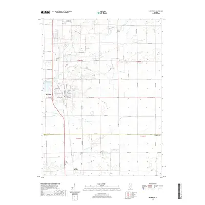
2018 Map of Heyworth
USGS Topo · Published 2018About this map
Heyworth serves as the primary hub in this central Illinois landscape, situated at the junction of Dixie Rd and W Cleveland St. The village is surrounded by a dense network of country roads, including W Randolph St, which connect it to smaller settlements like Randolph to the north and Bucks and Carle Springs to the south. This area, straddling the McLean and De Witt County line, is defined by the drainage systems of Kickapoo Creek and its many tributaries, such as Little Kickapoo Cr and Long Point Cr. For genealogists, the map is remarkably well-documented with rural burial grounds, including the Old Rutledge, Diamond Grove, and Saint Patricks cemeteries. Small-scale aviation is represented by Johnson Airport near the center of the quadrangle, tucked away among the farm sections of t22n r2e.
Find a feature on this map
60 named features on this map. Tap any name to fly to it.
Don’t see what you’re looking for? This feature index may not catch every label — zoom into the map to look around manually.
Map Details
Editions of this 2018 Heyworth Map
This is the sole edition of this map. No revisions or reprints were ever made.
Other maps of this area

1949 · Mc Lean
USGS Topo · 1:62,500

1951 · McLean
USGS Topo · 1:62,500

1951 · Le Roy
USGS Topo · 1:62,500

1957 · Kenney
USGS Topo · 1:62,500

1957 · Maroa
USGS Topo · 1:62,500

1958 · Peoria
USGS Topo · 1:250,000

1961 · Peoria
USGS Topo · 1:250,000

1963 · Peoria
USGS Topo · 1:250,000

1979 · De Witt
USGS Topo · 1:24,000
1979 · Clinton
USGS Topo · 1:24,000