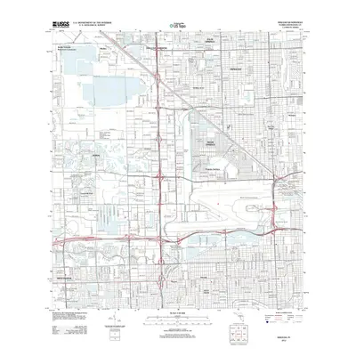
2012 Map of Hialeah
USGS Topo · Published 2012About this map
Hialeah and Miami Springs are depicted here in a phase of dense urban maturity, defined by the heavy infrastructure of the Miami International Airport and the complex industrial corridor along the Little River Canal. The landscape is a lattice of residential neighborhoods like Holiday Acres and Sun-Tan Village interspersed with large-scale recreational and commercial footprints. Notable among these are the historic Hialeah Race Track and the Hialeah Speedway, which reflect the region's long-standing connection to spectator sports. To the south, the academic presence of the Florida International University Tamiami Campus anchors the map, while the eastern edge is defined by the maritime commerce of Eisenberg Wharf and various air-marine terminals. Several significant cemeteries, including Mount Nebo Cem and Graceland Memorial Park, provide essential points of interest for genealogists tracing local family history.
Find a feature on this map
66 named features on this map. Tap any name to fly to it.
Don’t see what you’re looking for? This feature index may not catch every label — zoom into the map to look around manually.
Map Details
Editions of this 2012 Hialeah Map
This is the sole edition of this map. No revisions or reprints were ever made.
Other maps of this area

1947 · North Miami
USGS Topo · 1:24,000

1947 · Key Biscayne
USGS Topo · 1:24,000

1949 · Opalocka
USGS Topo · 1:24,000

1949 · South Miami NW
USGS Topo · 1:24,000

1949 · Key Biscayne
USGS Topo · 1:24,000

1950 · Hialeah
USGS Topo · 1:24,000

1950 · Miami
USGS Topo · 1:24,000

1950 · North Miami
USGS Topo · 1:24,000

1950 · South Miami
USGS Topo · 1:24,000

1955 · South Miami NW
USGS Topo · 1:24,000