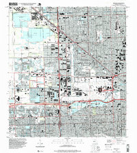
1994 Map of Hialeah
USGS Topo · Published 1999About this map
Hialeah Race Track and the sprawling Miami International Airport dominate this mid-1990s landscape of northwest Miami-Dade. The map documents a dense suburban and industrial corridor defined by an intricate network of waterways like the Miami Canal and Little River Canal (No C-7), which run alongside major transit arteries including the Palmetto Expressway and Okeechobee Road. In Hialeah and Miami Springs, residential grids are interspersed with local landmarks such as Palm Springs General Hospital and Hialeah Speedway. To the west, the massive Quarry operations in Medley provide a stark contrast to the institutional presence of the Florida International Univ (Tamiami Campus) and the U.S. Reservation (FAA). The sheet is particularly rich in cemeteries, including Lakeside Memorial Park and Flagler Mem Park Cem, offering significant value for genealogical research.
Find a feature on this map
87 named features on this map. Tap any name to fly to it.
Don’t see what you’re looking for? This feature index may not catch every label — zoom into the map to look around manually.
Map Details
Editions of this 1994 Hialeah Map
This is the sole edition of this map. No revisions or reprints were ever made.
Other maps of this area

1947 · North Miami
USGS Topo · 1:24,000

1947 · Key Biscayne
USGS Topo · 1:24,000

1949 · Opalocka
USGS Topo · 1:24,000

1949 · South Miami NW
USGS Topo · 1:24,000

1949 · Key Biscayne
USGS Topo · 1:24,000

1950 · Hialeah
USGS Topo · 1:24,000

1950 · Miami
USGS Topo · 1:24,000

1950 · North Miami
USGS Topo · 1:24,000

1950 · South Miami
USGS Topo · 1:24,000

1955 · South Miami NW
USGS Topo · 1:24,000