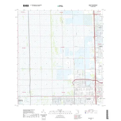
2021 Map of Hialeah SW
USGS Topo · Published 2021About this map
The Everglades landscape dominates the western half of this region, meeting the expanding suburban infrastructure of western Miami-Dade County. This modern survey illustrates the sharp contrast between the preserved wetlands of Everglades National Park and the highly organized grid of Doral and Tamiami. The hydraulic management of South Florida is evident through the engineered paths of the Agricultural Canal, Tamiami Canal Number C-4, and Snapper Creek Canal Number C-2. Development is dense along the eastern corridor, where Florida International University and the Our Lady of Mercy Catholic Cem serve as prominent local landmarks. Major transit arteries like Doral Blvd and W Flagler St facilitate movement through this once-impenetrable marshland, showing how the mid-21st century landscape has balanced ecological preservation with urban necessity.
Find a feature on this map
69 named features on this map. Tap any name to fly to it.
Don’t see what you’re looking for? This feature index may not catch every label — zoom into the map to look around manually.
Map Details
Editions of this 2021 Hialeah SW Map
This is the sole edition of this map. No revisions or reprints were ever made.
Other maps of this area

1949 · Opalocka
USGS Topo · 1:24,000

1949 · South Miami NW
USGS Topo · 1:24,000

1950 · Hialeah
USGS Topo · 1:24,000

1950 · South Miami
USGS Topo · 1:24,000

1955 · South Miami NW
USGS Topo · 1:24,000

1956 · South Miami
USGS Topo · 1:24,000

1956 · Miami
USGS Topo · 1:250,000

1958 · Miami
USGS Topo · 1:250,000
1962 · Hialeah
USGS Topo · 1:24,000

1962 · Opa-locka
USGS Topo · 1:24,000
Featured Places
- Lil Abner Mobile Home Park, FL
- University Lakes Mobile Home Park, FL
- Tamiami, FL
- Miami-Dade County, FL
- United States