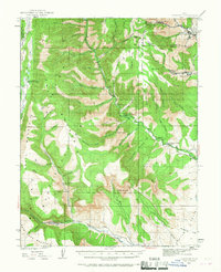
1923 Map of Hiawatha
USGS Topo · Published 1967About this map
The high-altitude coal mining operations of the Wasatch Plateau define this 1920s topography, showing the industrial infrastructure established along the borders of Carbon and Emery counties. The settlement of Hiawatha and the nearby Mohrland are central to this landscape, both serving as hubs for extensive extraction efforts at the Hiawatha Mine and the Mohrland Mine. The Utah RR provides the vital connection for moving coal from these remote canyons down toward the valleys. In the canyons below Gentry Mountain, smaller operations like the Huntington Mine and Old Johnson Mine dot the drainage of Huntington Creek. Away from the industrial zones, the map records the early administrative presence of the Forest Service at Upper Joes Ranger Station and Bear Creek Ranger Station, alongside family outposts like Brockbank Ranch and Swaseys Ranch in the lower flats of Castle Valley.
Find a feature on this map
73 named features on this map. Tap any name to fly to it.
Don’t see what you’re looking for? This feature index may not catch every label — zoom into the map to look around manually.
Map Details
Editions of this 1923 Hiawatha Map
4 editions found
Other maps of this area

1885 · Manti
USGS Topo · 1:250,000

1886 · Price River
USGS Topo · 1:250,000

1895 · Manti
USGS Topo · 1:250,000

1896 · Price River
USGS Topo · 1:250,000

1914 · Castle Gate
USGS Topo · 1:62,500

1916 · Castle Gate
USGS Topo · 1:62,500

1922 · Wasatch
USGS Topo · 1:31,680

1923 · Scofield
USGS Topo · 1:62,500

1923 · Castle Dale
USGS Topo · 1:62,500

1923 · Hiawatha
USGS Topo · 1:62,500