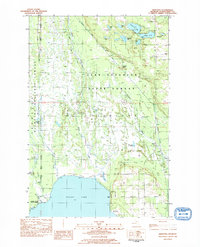
1983 Map of Hiawatha
USGS Topo · Published 1984About this map
Indian Lake dominates the southern landscape of this Upper Peninsula survey, where the marshy waters of the Spreads and Dead Creek filter into the northern basin. The terrain is defined by a dense network of glacial lakes including Ghost Lake, Kepler Lake, and Dodge Lake, many of which are contained within the Lake Superior State Forest. The map captures the small community of Hiawatha and the nearby Hiawatha Cem, marking a quiet pocket of settlement amidst the sprawling timberlands.
Find a feature on this map
34 named features on this map. Tap any name to fly to it.
Don’t see what you’re looking for? This feature index may not catch every label — zoom into the map to look around manually.
Map Details
Editions of this 1983 Hiawatha Map
This is the sole edition of this map. No revisions or reprints were ever made.
Other maps of this area

1931 · Cooks NE
USGS Topo · 1:31,680

1931 · Steuben SE
USGS Topo · 1:31,680

1931 · Steuben SW
USGS Topo · 1:31,680

1931 · Steuben NE
USGS Topo · 1:31,680

1931 · Cooks NW
USGS Topo · 1:31,680

1931 · Steuben NW
USGS Topo · 1:31,680

1931 · Manistique River NW
USGS Topo · 1:31,680

1931 · Manistique River SW
USGS Topo · 1:31,680

1954 · Escanaba
USGS Topo · 1:250,000

1957 · Escanaba
USGS Topo · 1:250,000