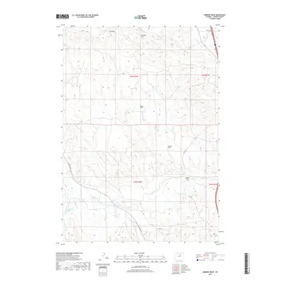
2017 Map of Hibbard Draw
USGS Topo · Published 2017About this map
The N Fork Powder River carves through the southern landscape of this Johnson County quadrangle, defining the local drainage and agricultural patterns. To the north, the terrain is dominated by high plateaus and extensive draws, most notably The Mesa and Antelope Draw. This ranching country is marked by significant irrigation infrastructure, such as the Broughton Ditch and Jim Blaine Ditch, which redirect water toward the arid lowlands. The presence of the Round Rock Reservoir in the southwest corner further illustrates the importance of water management in this high-plains environment. Transportation routes like Mayworth Rd and Old Hwy 191 follow the natural contours of the land, connecting disparate ranch sites across a region defined by its complex network of seasonal watercourses, including Hibbard Draw and Kuiper Draw.
Find a feature on this map
19 named features on this map. Tap any name to fly to it.
Don’t see what you’re looking for? This feature index may not catch every label — zoom into the map to look around manually.
Map Details
Editions of this 2017 Hibbard Draw Map
This is the sole edition of this map. No revisions or reprints were ever made.
Other maps of this area

1955 · Arminto
USGS Topo · 1:250,000

1958 · Arminto
USGS Topo · 1:250,000

1961 · Barnum
USGS Topo · 1:62,500

1961 · Kaycee NE
USGS Topo · 1:24,000

1961 · Dry Creek Reservoir
USGS Topo · 1:24,000

1961 · Antelope Draw
USGS Topo · 1:24,000

1961 · Schlict Draw
USGS Topo · 1:24,000

1961 · Hibbard Draw
USGS Topo · 1:24,000

1961 · Kaycee
USGS Topo · 1:24,000

1962 · Arminto
USGS Topo · 1:250,000