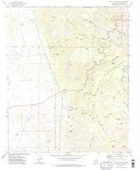
1973 Map of Hickey Mountain
USGS Topo · Published 1977About this map
Prescott National Forest dominates this Yavapai County terrain, where the high ridges of Woodchute Mtn and Hickey Mountain overlook a landscape defined by deep canyons and scattered mining operations. The extraction history of the Black Hills is evident in features like the Yaeger Mine in Yaeger Canyon and the Jerome Grande Shaft to the northeast. These sites, along with various Prospect labels and Tailings piles, reflect the intense mineral exploration that once pulsed through these mountains.
Find a feature on this map
77 named features on this map. Tap any name to fly to it.
Don’t see what you’re looking for? This feature index may not catch every label — zoom into the map to look around manually.
Map Details
Editions of this 1973 Hickey Mountain Map
3 editions found
Other maps of this area

1887 · Prescott
USGS Topo · 1:250,000

1892 · Prescott
USGS Topo · 1:250,000

1905 · Jerome
USGS Topo · 1:125,000

1944 · Clarkdale
USGS Topo · 1:48,000

1944 · Mingus Mountain
USGS Topo · 1:62,500

1947 · Mingus Mtn
USGS Topo · 1:62,500

1947 · Paulden
USGS Topo · 1:62,500

1947 · Prescott
USGS Topo · 1:62,500

1948 · Prescott
USGS Topo · 1:62,500
1948 · Clarkdale
USGS Topo · 1:62,500