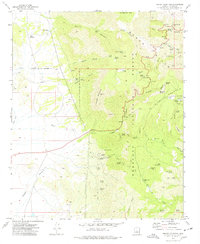
1973 Map of Hickey Mountain
USGS Topo · Published 1977About this map
The Black Hills of Yavapai County dominate this mid-1970s survey, illustrating a landscape defined by ranching, mining, and timber management. High-elevation landmarks like Hickey Mountain and Woodchute Mtn are surrounded by the deep drainage of Martin Canyon and Haywood Canyon. Evidence of the region’s industrial history is visible at the Jerome Grande Shaft and the Yaeger Mine, the latter located near the Yaeger Pack Trail.
Find a feature on this map
73 named features on this map. Tap any name to fly to it.
Don’t see what you’re looking for? This feature index may not catch every label — zoom into the map to look around manually.
Map Details
Editions of this 1973 Hickey Mountain Map
3 editions found
Other maps of this area

1887 · Prescott
USGS Topo · 1:250,000

1892 · Prescott
USGS Topo · 1:250,000

1905 · Jerome
USGS Topo · 1:125,000

1944 · Clarkdale
USGS Topo · 1:48,000

1944 · Mingus Mountain
USGS Topo · 1:62,500

1947 · Mingus Mtn
USGS Topo · 1:62,500

1947 · Paulden
USGS Topo · 1:62,500

1947 · Prescott
USGS Topo · 1:62,500

1948 · Prescott
USGS Topo · 1:62,500
1948 · Clarkdale
USGS Topo · 1:62,500