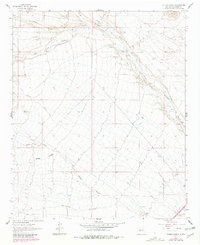
1961 Map of Hickman Ranch
USGS Topo · Published 1981About this map
Hickman Ranch and Scott Ranch anchor this arid Socorro County landscape, illustrating the remote ranching operations of the high desert during the mid-20th century. The terrain is defined by a dense network of drainage systems, most notably the long stretch of Milligan Gulch and the winding course of San Juan Canyon. These seasonal waterways create a complex topography of ridges and breaks, marked by survey points such as Vabm Sheep and Vabm Donna. The map reveals a land shaped by water erosion and sparse human footprint, where unimproved roads follow the natural contours of Red Canyon and North Canyon. Compiled from 1958 photography and updated with 1978 aerial data, this study documents the livestock-driven economy and land use patterns in the foothills of the Magdalena Mountains.
Find a feature on this map
13 named features on this map. Tap any name to fly to it.
Don’t see what you’re looking for? This feature index may not catch every label — zoom into the map to look around manually.
Map Details
Editions of this 1961 Hickman Ranch Map
2 editions found
Other maps of this area

1954 · Tularosa
USGS Topo · 1:250,000

1958 · Tularosa
USGS Topo · 1:250,000

1961 · Hickman Ranch
USGS Topo · 1:24,000

1961 · Paraje Well
USGS Topo · 1:24,000

1961 · Black Hill
USGS Topo · 1:24,000

1961 · Fort Craig
USGS Topo · 1:24,000

1964 · San Juan Peak
USGS Topo · 1:24,000

1964 · Steel Hill
USGS Topo · 1:24,000
1965 · Tenmile Hill
USGS Topo · 1:24,000
1965 · Puertecito Gap
USGS Topo · 1:24,000