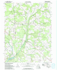
1993 Map of Hickman
USGS Topo · Published 1993About this map
Marshyhope Creek and its complex network of drainage ditches, such as the Short and Hall Ditch, define the agricultural landscape along the Maryland and Delaware border in the early 1990s. The region is dotted with small rural crossroads and settlements like Hickman and Adamsville, where life centered around local institutions like Todds Ch and the Ledenham School. The map illustrates a transition from the structured farm plots of Sussex Co to the conservation lands of the Idylwild State Wildlife Management Area in the southwest.
Find a feature on this map
63 named features on this map. Tap any name to fly to it.
Don’t see what you’re looking for? This feature index may not catch every label — zoom into the map to look around manually.
Map Details
Editions of this 1993 Hickman Map
This is the sole edition of this map. No revisions or reprints were ever made.
Other maps of this area

1905 · Denton
USGS Topo · 1:62,500

1905 · Hurlock
USGS Topo · 1:62,500

1915 · Seaford
USGS Topo · 1:62,500

1918 · Harrington
USGS Topo · 1:62,500

1944 · Denton
USGS Topo · 1:31,680

1944 · Federalsburg
USGS Topo · 1:31,680

1944 · Seaford
USGS Topo · 1:62,500

1944 · Hobbs
USGS Topo · 1:31,680
1944 · Harrington
USGS Topo · 1:62,500

1946 · Salisbury
USGS Topo · 1:250,000