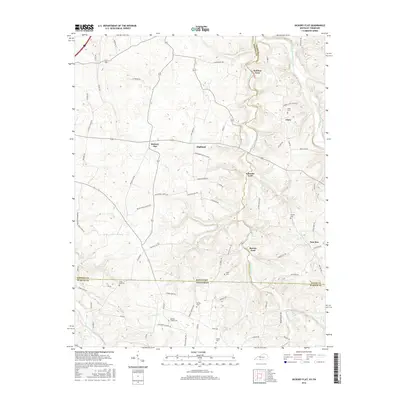
2016 Map of Hickory Flat
USGS Topo · Published 2016About this map
The rolling hills of the Kentucky Tennessee borderland are defined by the winding course of Sulphur Fork Creek and its many historic crossings. This landscape is a patchwork of small communities like Hickory Flat, Highland, and Clare, connected by a dense network of country roads including Vinegar Hill Rd and Perrytown Rd. The area maintains a strong connection to its pioneer roots, as evidenced by numerous family-named landmarks and crossings such as McElroy Ford, Eubanks Ford, and Bornes Ford. Genealogists will find significant value in the distribution of small burying grounds scattered across the countryside, including State Line Cem situated precisely on the border, and Martins Chapel Cem to the south. The terrain is deeply etched by the drainage of Middle Fork Drakes Creek and Smyrna Cr, shaping the rural character of this border region.
Find a feature on this map
80 named features on this map. Tap any name to fly to it.
Don’t see what you’re looking for? This feature index may not catch every label — zoom into the map to look around manually.
Map Details
Editions of this 2016 Hickory Flat Map
This is the sole edition of this map. No revisions or reprints were ever made.
Other maps of this area

1921 · Bowling Green
USGS Topo · 1:62,500

1923 · Bowling Green
USGS Topo · 1:62,500

1928 · Adolphus
USGS Topo · 1:48,000

1931 · Adolphus
USGS Topo · 1:62,500

1942 · Gallatin
USGS Topo · 1:100,000

1951 · Woodburn
USGS Topo · 1:24,000

1951 · Franklin
USGS Topo · 1:24,000

1954 · Drake
USGS Topo · 1:24,000
1954 · Hickory Flat
USGS Topo · 1:24,000

1954 · Adolphus
USGS Topo · 1:24,000