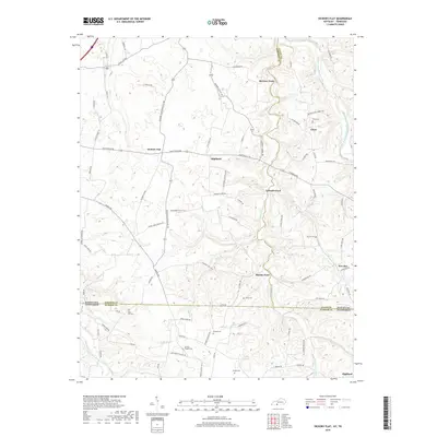
2019 Map of Hickory Flat
USGS Topo · Published 2019About this map
Hickory Flat and Highland anchor this rural landscape straddling the state line between Kentucky and Tennessee. The terrain is defined by the winding course of Sulphur Fork Creek and its tributaries, which carved numerous crossings like Eubanks Ford and McElroy Ford. This 2019 survey documents a region where transportation and community life are still closely tied to historical water access and family lineages, evidenced by the density of small cemeteries scattered across the ridge tops and creek valleys.
Find a feature on this map
87 named features on this map. Tap any name to fly to it.
Don’t see what you’re looking for? This feature index may not catch every label — zoom into the map to look around manually.
Map Details
Editions of this 2019 Hickory Flat Map
This is the sole edition of this map. No revisions or reprints were ever made.
Other maps of this area

1921 · Bowling Green
USGS Topo · 1:62,500

1923 · Bowling Green
USGS Topo · 1:62,500

1928 · Adolphus
USGS Topo · 1:48,000

1931 · Adolphus
USGS Topo · 1:62,500

1942 · Gallatin
USGS Topo · 1:100,000

1951 · Woodburn
USGS Topo · 1:24,000

1951 · Franklin
USGS Topo · 1:24,000

1954 · Drake
USGS Topo · 1:24,000
1954 · Hickory Flat
USGS Topo · 1:24,000

1954 · Adolphus
USGS Topo · 1:24,000