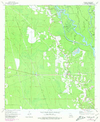
1971 Map of Hickory
USGS Topo · Published 1980About this map
Hickory and the surrounding piney woods of St. Tammany Parish are defined by the complex hydrology of the West Pearl River and its intricate distributaries. This landscape, surveyed in the late 1960s with revisions through the late 1970s, shows a community deeply tied to the land through extractive industries and river navigation. Local infrastructure is anchored by Lock No 1 and the Gulf Mobile and Ohio railroad line, while several sand and gravel pits indicate the area's economic base. Genealogists will find a high concentration of family-named landmarks and burial sites, including the Witch Cem, Evans Creek Cem, and Austin Cem. The transition from the higher ground near the Hickory Lookout Tower to the bottomlands of Holmes Island and Pats Hammock illustrates the traditional settlement patterns of the Louisiana-Mississippi borderlands.
Find a feature on this map
49 named features on this map. Tap any name to fly to it.
Don’t see what you’re looking for? This feature index may not catch every label — zoom into the map to look around manually.
Map Details
Editions of this 1971 Hickory Map
4 editions found
Other maps of this area

1914 · Nicholson
USGS Topo · 1:62,500

1921 · Nicholson
USGS Topo · 1:62,500

1935 · Slidell
USGS Topo · 1:62,500

1939 · Slidell
USGS Topo · 1:62,500

1941 · Honey Island
USGS Topo · 1:31,680

1942 · Talisheek
USGS Topo · 1:31,680

1942 · Walkiah Bluff
USGS Topo · 1:31,680

1950 · Haaswood
USGS Topo · 1:31,680

1950 · Slidell
USGS Topo · 1:62,500

1953 · Mobile
USGS Topo · 1:250,000