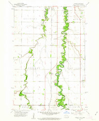
1959 Map of Hickson
USGS Topo · Published 1963About this map
The Red River of the North forms a serpentine border between North Dakota and Minnesota in this 1959 study, its tight meanders carving through a landscape defined by the townships of Stanley, Kurtz, Pleasant, and Holy Cross. Parallel to the river, the Chicago Milwaukee St Paul and Pacific railroad anchors the agricultural settlements of Wild Rice and Hickson, while the Wild Rice River winds through the western half of the quadrangle.
Find a feature on this map
24 named features on this map. Tap any name to fly to it.
Don’t see what you’re looking for? This feature index may not catch every label — zoom into the map to look around manually.
Map Details
Editions of this 1959 Hickson Map
3 editions found
Other maps of this area

1895 · Fargo
USGS Topo · 1:125,000

1897 · Fargo
USGS Topo · 1:125,000

1953 · Fargo
USGS Topo · 1:250,000

1956 · Fargo
USGS Topo · 1:250,000

1959 · South West Fargo
USGS Topo · 1:24,000

1959 · Fargo South
USGS Topo · 1:24,000

1959 · Hickson
USGS Topo · 1:24,000
1959 · Walcott
USGS Topo · 1:24,000

1959 · Christine
USGS Topo · 1:24,000
1959 · Norman
USGS Topo · 1:24,000