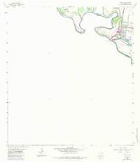
1963 Map of Hidalgo
USGS Topo · Published 1984About this map
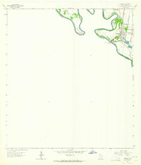
The Rio Grande defines the international boundary in this 1960s study, where the oxbows of Rincon Bend and Coyote Banco No 85 reflect the shifting nature of the river border between the United States and Mexico. The settlement of Hidalgo serves as a critical junction, anchored by the Mc Allen-Hidalgo-Reynosa Toll Bridge and the U S Custom house. This map illustrates the vital water infrastructure of the Rio Grande Valley, including the Pharr-San Juan Pumping Sta and the Mc Allen Main Canal, which were essential to the region's agricultural development. The landscape is also dotted with energy exploration, evidenced by scattered Gas Wells, and recreation or storage at Lake Tropicana and Lake Texano. The Missouri Pacific railroad further highlights the area's role as a transit corridor for goods crossing between Texas and Tamaulipas.
Find a feature on this map
18 named features on this map. Tap any name to fly to it.
Don’t see what you’re looking for? This feature index may not catch every label — zoom into the map to look around manually.
Map Details
Editions of this 1963 Hidalgo Map
2 editions found
Other maps of this area

1914 · San Juan
USGS Topo · 1:48,000

1916 · San Juan
USGS Topo · 1:62,500

1949 · Mc Allen
USGS Topo · 1:250,000

1954 · McAllen
USGS Topo · 1:250,000

1957 · Mc Allen
USGS Topo · 1:250,000

1962 · McAllen
USGS Topo · 1:250,000
1962 · Las Milpas
USGS Topo · 1:24,000

1963 · La Joya
USGS Topo · 1:24,000
1963 · Hidalgo
USGS Topo · 1:24,000
1963 · Mission
USGS Topo · 1:24,000