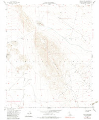
1954 Map of Hidalgo Mtn
USGS Topo · Published 1983About this map
Hidalgo Mtn dominates the high desert landscape of this San Bernardino County survey, which captures the region during a period of transition into a dedicated military exercise area. Much of the terrain is defined by the Marine Corps Training Center, illustrating the mid-century expansion of defense infrastructure into the California interior. Despite the military presence, the map preserves evidence of earlier resource extraction and ranching, such as the Crystal Mine and a Mill situated near Ames Well. The hydrology of the area is represented by seasonal dry features like Quackenbush Lake and Emerson Lake, which sit at the base of the mountains. Several Well sites and a network of Jeep Trails snake through the arid flats, providing a clear record of 20th-century desert navigation and land use.
Find a feature on this map
12 named features on this map. Tap any name to fly to it.
Don’t see what you’re looking for? This feature index may not catch every label — zoom into the map to look around manually.
Map Details
Editions of this 1954 Hidalgo Mtn Map
4 editions found
Other maps of this area

1953 · San Bernardino
USGS Topo · 1:250,000

1954 · Galway Lake
USGS Topo · 1:24,000

1954 · Hidalgo Mtn
USGS Topo · 1:24,000

1954 · Emerson Lake
USGS Topo · 1:24,000

1955 · Deadman Lake NW
USGS Topo · 1:24,000

1955 · Lavic SE
USGS Topo · 1:24,000

1955 · Goat Mountain
USGS Topo · 1:24,000

1955 · Morgans Well
USGS Topo · 1:24,000

1955 · Deadman Lake SW
USGS Topo · 1:24,000

1955 · Lavic
USGS Topo · 1:62,500