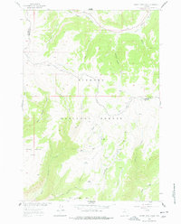
1960 Map of Hidden Tepee Creek
USGS Topo · Published 1978About this map
Bighorn National Forest dominates this 1960s survey, revealing a landscape defined by seasonal grazing and high-altitude drainage systems. The presence of the Horse Creek Cow Camp near the center of the sheet indicates the area's continued importance for livestock management within the national forest system. The drainage patterns of the North Tongue River and Hidden Tepee Creek carve through the high plateaus, separating prominent flat-topped features like Horse Creek Mesa and Sunlight Mesa.
Find a feature on this map
26 named features on this map. Tap any name to fly to it.
Don’t see what you’re looking for? This feature index may not catch every label — zoom into the map to look around manually.
Map Details
Editions of this 1960 Hidden Tepee Creek Map
2 editions found
Other maps of this area

1898 · Bald Mountain
USGS Topo · 1:125,000

1901 · Bald Mountain
USGS Topo · 1:125,000

1955 · Sheridan
USGS Topo · 1:250,000

1958 · Sheridan
USGS Topo · 1:250,000

1960 · Shell Falls
USGS Topo · 1:24,000

1960 · Black Mountain
USGS Topo · 1:24,000

1960 · Granite Pass
USGS Topo · 1:24,000

1960 · Hidden Tepee Creek
USGS Topo · 1:24,000

1960 · Shell
USGS Topo · 1:24,000
1960 · Bald Mountain
USGS Topo · 1:24,000