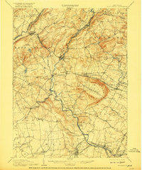
1905 Map of High Bridge
USGS Topo · Published 1917About this map
Cushetunk Mountain forms a dramatic horseshoe-shaped ridge around Round Valley, a defining geological landmark in this early twentieth-century survey of Hunterdon County. The landscape is a complex network of narrow valleys and ridges, where the Musconetcong River and South Branch Raritan River provide the primary drainage. This era was defined by intense rail activity, with the Central Railroad of New Jersey and the Lehigh Valley RR intersecting at key junctions. The town of Flemington sits at a major rail terminus in the south, while the High Bridge Branch winds north through steep terrain. Smaller nineteenth-century settlements such as Glen Gardner, Junction, and Quakertown are shown in their original orientations, many serving as local centers for the surrounding agrarian townships before the expansion of the modern highway system redefined the region.
Find a feature on this map
105 named features on this map. Tap any name to fly to it.
Don’t see what you’re looking for? This feature index may not catch every label — zoom into the map to look around manually.
Map Details
Editions of this 1905 High Bridge Map
4 editions found
Other maps of this area

1888 · Hackettstown
USGS Topo · 1:62,500

1888 · Princeton
USGS Topo · 1:62,500

1888 · Lake Hopatcong
USGS Topo · 1:62,500

1890 · Easton
USGS Topo · 1:62,500

1890 · High Bridge
USGS Topo · 1:62,500

1890 · Lambertville
USGS Topo · 1:62,500

1890 · Doylestown
USGS Topo · 1:62,500

1891 · Somerville
USGS Topo · 1:62,500

1891 · Easton
USGS Topo · 1:62,500

1891 · Lambertville
USGS Topo · 1:62,500