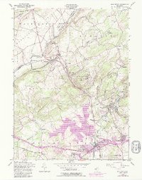
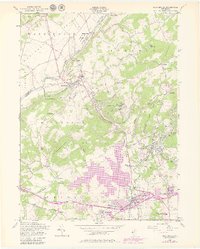
1954 Map of High Bridge
USGS Topo · Published 1979About this map
Voorhees State Park and the rising waters of the Spruce Run Reservoir dominate this Hunterdon County landscape, where the ridges of Washington Mtn and Musconetcong Mountain funnel transportation and settlement into narrow valleys. The region’s institutional history is anchored by the State Sanatorium atop Mt Kipp and the State Reformatory near the southern edge. The industrial and transit corridor is clearly defined by the Central Railroad of New Jersey and the Lehigh Valley line, which served towns like High Bridge and Glen Gardner. Local life centers around rural landmarks such as the Musconetcong Valley Ch, the Stone Mill on the Raritan River, and various cemeteries like Evergreen Cem and Immaculate Conception Cem. Purple-shaded revisions show the mid-century expansion of Annandale, Clinton, and Hampton, reflecting the area's growth during the postwar years.
Find a feature on this map
75 named features on this map. Tap any name to fly to it.
Don’t see what you’re looking for? This feature index may not catch every label — zoom into the map to look around manually.
Map Details
Editions of this 1954 High Bridge Map
5 editions found
Other maps of this area

1888 · Hackettstown
USGS Topo · 1:62,500

1890 · Easton
USGS Topo · 1:62,500

1890 · High Bridge
USGS Topo · 1:62,500

1891 · Easton
USGS Topo · 1:62,500

1891 · Delaware Water Gap
USGS Topo · 1:62,500

1893 · Delaware Water Gap
USGS Topo · 1:62,500

1894 · Hackettstown
USGS Topo · 1:62,500

1898 · Hackettstown
USGS Topo · 1:62,500

1898 · High Bridge
USGS Topo · 1:62,500

1900 · Raritan
USGS Topo · 1:125,000