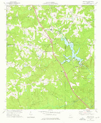
1973 Map of High Falls
USGS Topo · Published 1976About this map
The Towaliga River powers through this Central Georgia landscape, forming the centerpiece of High Falls State Park where it drops over the terrain's natural granite outcroppings. By the early 1970s, the impounded High Falls Lake had transformed the local geography, creating a recreation hub with a Boat Ramp and multiple campgrounds. This era shows a complex mix of land use, from the institutional presence of the State Dept of Corrections Diagnostic Center to rural hamlets like Patillo and Unionville. Evidence of the area's industrial past remains at Higgins Mill on the river's lower reaches, while the backcountry is dotted with local heritage sites including High Shoals Ch and Rock Springs Ch. A unique detail of this survey is the inclusion of fine red dashed lines indicating specific fence and field lines, providing a granular view of 1970s land divisions and agrarian patterns.
Find a feature on this map
39 named features on this map. Tap any name to fly to it.
Don’t see what you’re looking for? This feature index may not catch every label — zoom into the map to look around manually.
Map Details
Editions of this 1973 High Falls Map
2 editions found
Other maps of this area

1951 · Forsyth
USGS Topo · 1:62,500

1951 · Barnesville
USGS Topo · 1:62,500

1953 · Atlanta
USGS Topo · 1:250,000

1953 · Athens
USGS Topo · 1:250,000

1957 · Atlanta
USGS Topo · 1:250,000

1958 · Athens
USGS Topo · 1:250,000

1958 · Atlanta
USGS Topo · 1:250,000

1959 · Athens
USGS Topo · 1:250,000

1963 · Athens
USGS Topo · 1:250,000

1964 · Luella
USGS Topo · 1:24,000