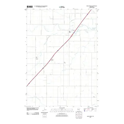
2010 Map of High Forest
USGS Topo · Published 2010About this map
High Forest serves as a central landmark in this Olmsted County landscape, where the North Branch Root River carves through the local topography. This 2010 USGS study captures a rural geography defined by a strong network of local family and community history, evidenced by the numerous burial grounds scattered across the quadrangle. From the High Forest Cemetery and Saint Johns Cemetery in the north to the Salem Cemetery in the southeast, these sites provide essential data for genealogists tracing ancestral roots in the Stewartville area.
Find a feature on this map
48 named features on this map. Tap any name to fly to it.
Don’t see what you’re looking for? This feature index may not catch every label — zoom into the map to look around manually.
Map Details
Editions of this 2010 High Forest Map
This is the sole edition of this map. No revisions or reprints were ever made.
Other maps of this area

1954 · Mason City
USGS Topo · 1:250,000

1955 · Stewartville
USGS Topo · 1:62,500

1955 · High Forest
USGS Topo · 1:62,500

1957 · Mason City
USGS Topo · 1:250,000

1958 · Mason City
USGS Topo · 1:250,000

1965 · Dexter
USGS Topo · 1:24,000

1965 · Spring Valley
USGS Topo · 1:24,000

1965 · Grand Meadow
USGS Topo · 1:24,000
1974 · Rock Dell
USGS Topo · 1:24,000
1974 · High Forest
USGS Topo · 1:24,000