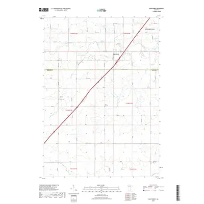
2019 Map of High Forest
USGS Topo · Published 2019About this map
High Forest and the southwestern outskirts of Stewartville anchor this landscape along the border of Olmsted and Mower counties. The terrain is defined by the winding paths of the North Branch Root River and its tributaries, including Robinson Creek and Carey Creek. This agricultural region is punctuated by several local burial grounds that serve as vital records for family historians, such as High Forest Cemetery, Pleasant Valley Cemetery, and Saint Johns Cemetery. Transportation is dominated by the modern diagonal corridor of the interstate, which cuts through traditional township lines like t105n r14w and t104n r14w. The map also traces smaller waterways like North Fork Bear Creek in the southern reaches, highlighting the drainage patterns that have shaped farm placement and road development in this part of Minnesota.
Find a feature on this map
66 named features on this map. Tap any name to fly to it.
Don’t see what you’re looking for? This feature index may not catch every label — zoom into the map to look around manually.
Map Details
Editions of this 2019 High Forest Map
This is the sole edition of this map. No revisions or reprints were ever made.
Other maps of this area

1954 · Mason City
USGS Topo · 1:250,000

1955 · Stewartville
USGS Topo · 1:62,500

1955 · High Forest
USGS Topo · 1:62,500

1957 · Mason City
USGS Topo · 1:250,000

1958 · Mason City
USGS Topo · 1:250,000

1965 · Dexter
USGS Topo · 1:24,000

1965 · Spring Valley
USGS Topo · 1:24,000

1965 · Grand Meadow
USGS Topo · 1:24,000
1974 · Rock Dell
USGS Topo · 1:24,000
1974 · High Forest
USGS Topo · 1:24,000