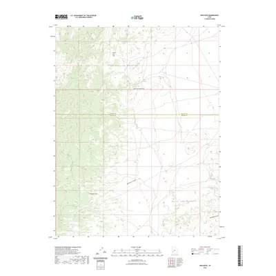
2023 Map of High Rock
USGS Topo · Published 2023About this map
The San Francisco Mountains and Little Frisco Mountains dominate this high-desert landscape along the boundary of Millard Co and Beaver Co. This survey documents a critical basin-and-range corridor defined by seasonal water sources and steep topographic transitions. Remote landmarks like High Rock Pass and James Spring speak to the area's history of prospecting and ranching, where reliable water was the primary driver of human activity. The map traces the natural drainage patterns of Sawmill Canyon and Morehouse Canyon, offering a detailed view of the terrain before it gives way to the Beaver Lake Mountains in the southeast. This modern update by the U.S. Geological Survey preserves the nomenclature of early western exploration, including uniquely named features like Three Kilns Spring and Brownfield Canyon.
Find a feature on this map
13 named features on this map. Tap any name to fly to it.
Don’t see what you’re looking for? This feature index may not catch every label — zoom into the map to look around manually.
Map Details
Editions of this 2023 High Rock Map
This is the sole edition of this map. No revisions or reprints were ever made.
Other maps of this area

1953 · Richfield
USGS Topo · 1:250,000

1958 · Richfield
USGS Topo · 1:250,000

1958 · Milford
USGS Topo · 1:62,500

1958 · Milford
USGS Topo · 1:24,000

1959 · Frisco
USGS Topo · 1:62,500

1960 · Frisco Peak
USGS Topo · 1:62,500

1960 · Beaver Lake Mts.
USGS Topo · 1:62,500

1980 · Wah Wah Mts. South
USGS Topo · 1:100,000

1980 · Wah Wah Mts. North
USGS Topo · 1:100,000
1989 · High Rock
USGS Topo · 1:24,000