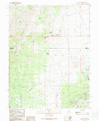
1989 Map of High Rock
USGS Topo · Published 1989About this map
The San Francisco Mountains and Beaver Lake Mountains dominate this landscape, which spans the high desert border of Millard Co and Beaver Co. This late-twentieth-century survey documents an area shaped by livestock and mineral extraction, where water sources like James Spring and Three Kilns Spring were essential for survival. The presence of Kilns and a Quarry in the north, alongside more intensive operations like the Black Rock Mine and Usmm 2 in the southeast, indicates a legacy of resource exploitation across the ridges. Topographical features such as High Rock Pass and the deep cuts of Morehouse Canyon and Sawmill Canyon illustrate the complex drainages of the Frisco Mountains. Numerous Prospects and Mine Shafts scattered through the hills offer a detailed view of the regional mining activity that defined this part of Utah.
Find a feature on this map
26 named features on this map. Tap any name to fly to it.
Don’t see what you’re looking for? This feature index may not catch every label — zoom into the map to look around manually.
Map Details
Editions of this 1989 High Rock Map
This is the sole edition of this map. No revisions or reprints were ever made.
Other maps of this area

1953 · Richfield
USGS Topo · 1:250,000

1958 · Richfield
USGS Topo · 1:250,000

1958 · Milford
USGS Topo · 1:62,500

1958 · Milford
USGS Topo · 1:24,000

1959 · Frisco
USGS Topo · 1:62,500

1960 · Frisco Peak
USGS Topo · 1:62,500

1960 · Beaver Lake Mts.
USGS Topo · 1:62,500

1980 · Wah Wah Mts. South
USGS Topo · 1:100,000

1980 · Wah Wah Mts. North
USGS Topo · 1:100,000
1989 · Frisco Peak
USGS Topo · 1:24,000