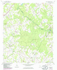
1964 Map of High Shoals
USGS Topo · Published 1986About this map
The Apalachee River carves a winding path through the borderlands of Walton, Oconee, and Morgan Counties, anchoring a landscape defined by small agrarian settlements and numerous rural congregations. In the town of Good Hope, the community identity is centered around landmarks like the Good Hope Peters Sch and nearby Bethel Ch, while the eastern portion of the sheet is dominated by the industrial and riverine history of High Shoals and North High Shoals. This 1964 survey, with 1985 photorevisions, captures the area during a period of transition, noting a Cotton Research Station and several family-named burial grounds such as Locklin Cem, McGaughey Cem, and Hale Cem that dot the countryside. The presence of Snows Mill and the elevation at Turkey Creek Mtn illustrate how the local topography influenced early settlement and industry along the region's many creeks and branches.
Find a feature on this map
56 named features on this map. Tap any name to fly to it.
Don’t see what you’re looking for? This feature index may not catch every label — zoom into the map to look around manually.
Map Details
Editions of this 1964 High Shoals Map
2 editions found
Other maps of this area

1896 · Monroe
USGS Topo · 1:125,000

1953 · Athens
USGS Topo · 1:250,000

1958 · Athens
USGS Topo · 1:250,000

1959 · Athens
USGS Topo · 1:250,000

1963 · Athens
USGS Topo · 1:250,000

1964 · Athens West
USGS Topo · 1:24,000

1964 · High Shoals
USGS Topo · 1:24,000

1964 · Watkinsville
USGS Topo · 1:24,000

1964 · Monroe
USGS Topo · 1:24,000

1964 · Winder South
USGS Topo · 1:24,000