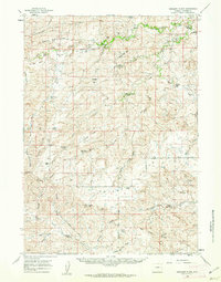
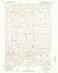
1959 Map of Highland Flats
USGS Topo · Published 1962About this map
The Cheyenne River and its Dry Fork Cheyenne River carve through this high plains landscape, defining the topography of Converse County. This 1959 field-checked survey reveals a territory organized around expansive ranching operations and water management, evidenced by the numerous flowing wells and the Silver Spoon Reservoir. Significant family-run holdings like the Hornbuckle Ranch and the Manning Ranch are scattered across the terrain, while the Eighty-Eight Ranch (Site) marks a point of earlier habitation. The landscape is characterized by its named elevations and depressions, from the prominently labeled Highland Flats to the curiously named Holdup Hollow and Suicide Hill. The network of unimproved roads and the distinctive Loop Road suggest the isolation and specific navigational needs of this ranching country before modern development altered these rural corridors.
Find a feature on this map
51 named features on this map. Tap any name to fly to it.
Don’t see what you’re looking for? This feature index may not catch every label — zoom into the map to look around manually.
Map Details
Editions of this 1959 Highland Flats Map
2 editions found
Other maps of this area
1949 · Sundquist Ranch
USGS Topo · 1:24,000
1949 · Gilbert Lake
USGS Topo · 1:24,000
1949 · Leuenberger Ranch
USGS Topo · 1:24,000

1949 · Hylton Ranch
USGS Topo · 1:24,000
1950 · Gilbert Lake
USGS Topo · 1:24,000
1950 · Leuenberger Ranch
USGS Topo · 1:24,000

1950 · Hylton Ranch
USGS Topo · 1:24,000
1950 · Sundquist Ranch
USGS Topo · 1:24,000

1954 · Torrington
USGS Topo · 1:250,000

1955 · Newcastle
USGS Topo · 1:250,000