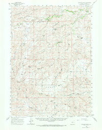
1959 Map of Highland Flats
USGS Topo · Published 1971About this map
Highland Flats and the surrounding high plains of Converse County are defined by a network of family-operated livestock operations and seasonal watercourses. The northern portion of the map is dominated by the Cheyenne River and its Dry Fork, where labels like River Flat Draw and Harland Flat indicate the critical role of river-bottom land in this arid environment. Ranching families have left a permanent mark on the landscape, with landmarks such as Hornbuckle Ranch, W Reynolds Ranch, and the Eighty-Eight Ranch (Site) serving as primary centers of activity.
Find a feature on this map
58 named features on this map. Tap any name to fly to it.
Don’t see what you’re looking for? This feature index may not catch every label — zoom into the map to look around manually.
Map Details
Editions of this 1959 Highland Flats Map
2 editions found
Other maps of this area

1949 · Sundquist Ranch
USGS Topo · 1:24,000

1949 · Gilbert Lake
USGS Topo · 1:24,000

1949 · Leuenberger Ranch
USGS Topo · 1:24,000

1949 · Hylton Ranch
USGS Topo · 1:24,000

1950 · Gilbert Lake
USGS Topo · 1:24,000

1950 · Leuenberger Ranch
USGS Topo · 1:24,000
1950 · Hylton Ranch
USGS Topo · 1:24,000
1950 · Sundquist Ranch
USGS Topo · 1:24,000

1954 · Torrington
USGS Topo · 1:250,000

1955 · Newcastle
USGS Topo · 1:250,000