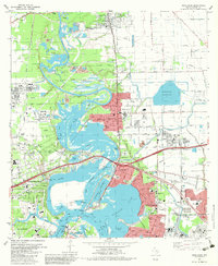
1982 Map of Highlands
USGS Topo · Published 1983About this map
The San Jacinto River and Buffalo Bayou converge at the heart of this coastal industrial landscape, anchoring the site of San Jacinto State Park. Here, the San Jacinto Monument and the permanently moored Battleship Texas overlook Burnet Bay, marking the site of the 1836 battle. The surrounding area reflects the heavy industrialization of the early 1980s, with extensive infrastructure including a massive Refinery complex and multiple chemical plants serving the Jacintoport and Baytown corridors.
Find a feature on this map
96 named features on this map. Tap any name to fly to it.
Don’t see what you’re looking for? This feature index may not catch every label — zoom into the map to look around manually.
Map Details
Editions of this 1982 Highlands Map
2 editions found
Other maps of this area

1915 · Deepwater
USGS Topo · 1:24,000

1916 · Burnett Bay
USGS Topo · 1:24,000

1916 · Crosby
USGS Topo · 1:24,000

1916 · Morgan Point
USGS Topo · 1:24,000

1916 · Fauna
USGS Topo · 1:24,000

1916 · Harmaston
USGS Topo · 1:24,000

1916 · Cedar Bayou
USGS Topo · 1:24,000

1916 · La Porte
USGS Topo · 1:24,000

1919 · Morgan Point
USGS Topo · 1:31,680

1919 · Deepwater
USGS Topo · 1:31,680