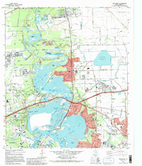
1982 Map of Highlands
USGS Topo · Published 1995About this map
The San Jacinto River and Buffalo Bayou converge in this 1980s landscape, a region defined by industrial expansion and significant Texas landmarks. San Jacinto State Park sits prominently at the confluence, protecting the site of the Historical Monument and the permanent mooring of the Battleship Texas. The surrounding area shows the dense infrastructure of the era, from the massive Highlands Reservoir to the complex network of canals and pipelines serving the nearby refineries of Baytown. Smaller residential enclaves like McNair and Barrett are situated alongside heavy industry and the winding course of the Old River. The map illustrates the specialized landscape of the Gulf Coast, where natural bayous like Carpenters Bayou meet engineered features such as the Lynchburg Reservoir, supporting the intensive maritime and petroleum operations that drove the local economy during this period of development.
Find a feature on this map
69 named features on this map. Tap any name to fly to it.
Don’t see what you’re looking for? This feature index may not catch every label — zoom into the map to look around manually.
Map Details
Editions of this 1982 Highlands Map
2 editions found
Other maps of this area

1915 · Deepwater
USGS Topo · 1:24,000

1916 · Burnett Bay
USGS Topo · 1:24,000

1916 · Crosby
USGS Topo · 1:24,000

1916 · Morgan Point
USGS Topo · 1:24,000

1916 · Fauna
USGS Topo · 1:24,000

1916 · Harmaston
USGS Topo · 1:24,000

1916 · Cedar Bayou
USGS Topo · 1:24,000

1916 · La Porte
USGS Topo · 1:24,000

1919 · Morgan Point
USGS Topo · 1:31,680

1919 · Deepwater
USGS Topo · 1:31,680