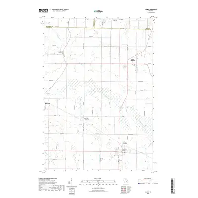
2018 Map of Hilbert
USGS Topo · Published 2018About this map
Hilbert Junction and the adjacent village of Hilbert anchor the southern portion of this Calumet County survey, where the regional drainage of the N Br Manitowoc River and Killsnake River shapes the low-lying terrain. The map documents a dense network of early crossroads settlements, including Forest Junction, Sherwood, and Dundas, each serving as a focal point for the surrounding dairy-country homesteads. Genealogists will find a high density of religious landmarks, with several denominations represented through the Saint Johns Catholic Cem, Saint John Lutheran Cem, and Saint Mary's Cem. A notable geographic feature is the Military Rd, a corridor that speaks to the era of early frontier transport, now integrated into the modern grid near Harrison. The landscape is characterized by its transition between these small hamlets and the expansive wetlands along the river forks.
Find a feature on this map
79 named features on this map. Tap any name to fly to it.
Don’t see what you’re looking for? This feature index may not catch every label — zoom into the map to look around manually.
Map Details
Editions of this 2018 Hilbert Map
This is the sole edition of this map. No revisions or reprints were ever made.
Other maps of this area

1911 · Neenah
USGS Topo · 1:62,500

1954 · De Pere
USGS Topo · 1:62,500

1954 · Chilton
USGS Topo · 1:62,500

1955 · Neenah
USGS Topo · 1:62,500

1955 · Appleton
USGS Topo · 1:62,500

1955 · Green Bay
USGS Topo · 1:250,000

1974 · Hilbert
USGS Topo · 1:24,000

1974 · Brillion
USGS Topo · 1:24,000
1974 · Chilton
USGS Topo · 1:24,000
1974 · Potter
USGS Topo · 1:24,000