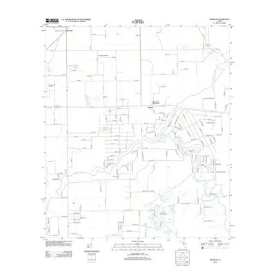
2012 Map of Hildreth
USGS Topo · Published 2012About this map
Beachville and Hildreth anchor this rural landscape in Suwannee County, where the hydrological systems of Northern Florida are the primary geographic drivers. The Sante Fe River snakes through the southern half of the map, joined by the Ichetucknee River flowing south from Ichetucknee Springs. This convergence creates a wetland-rich environment punctuated by numerous named bodies of water including Sampson Lake, Double Pond, and Grass Pond. Local history is preserved through family and community landmarks such as Hunts Cem, Santa Fe Cem, and the Ichetucknee Cem, while the Beachville Fire Tower stands as a sentinel over the surrounding timber and farmlands. Aviation is notably active in this quiet region, with Thompson Airfield, Flying C Farm Airport, and the Fox Field Stolport providing private and agricultural access points across the grid of county roads.
Find a feature on this map
166 named features on this map. Tap any name to fly to it.
Don’t see what you’re looking for? This feature index may not catch every label — zoom into the map to look around manually.
Map Details
Editions of this 2012 Hildreth Map
This is the sole edition of this map. No revisions or reprints were ever made.
Other maps of this area

1954 · Gainesville
USGS Topo · 1:250,000

1954 · Valdosta
USGS Topo · 1:250,000

1958 · Valdosta
USGS Topo · 1:250,000

1958 · Gainesville
USGS Topo · 1:250,000

1959 · Valdosta
USGS Topo · 1:250,000

1959 · Gainesville
USGS Topo · 1:250,000

1963 · Columbia
USGS Topo · 1:24,000

1968 · Branford
USGS Topo · 1:24,000

1968 · Hatchbend
USGS Topo · 1:24,000
1968 · Hildreth
USGS Topo · 1:24,000