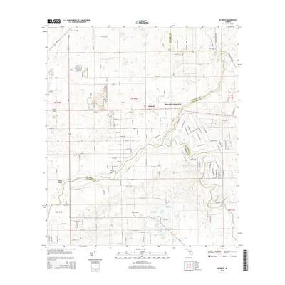
2015 Map of Hildreth
USGS Topo · Published 2015About this map
Beachville and Hildreth anchor this northern Florida landscape, situated within a complex network of county boundaries where Suwannee, Columbia, and Gilchrist counties converge. The terrain is defined by the winding course of the Ichetucknee River and the larger Santa Fe River, which together form a natural border for the region's agricultural and rural properties. Local transit relies on a grid of county roads and section lines, with Thompson Airfield and Flying C Farm 3 Airport serving the area's aviation needs. The map reveals a land heavily influenced by water, featuring numerous small bodies such as Fox Pond, Deer Pond, and Sampson Lake, which are characteristic of the region's karst topography and fluctuating water table.
Find a feature on this map
2 named features on this map. Tap any name to fly to it.
Don’t see what you’re looking for? This feature index may not catch every label — zoom into the map to look around manually.
Map Details
Editions of this 2015 Hildreth Map
This is the sole edition of this map. No revisions or reprints were ever made.
Other maps of this area

1954 · Gainesville
USGS Topo · 1:250,000

1954 · Valdosta
USGS Topo · 1:250,000

1958 · Valdosta
USGS Topo · 1:250,000

1958 · Gainesville
USGS Topo · 1:250,000

1959 · Valdosta
USGS Topo · 1:250,000

1959 · Gainesville
USGS Topo · 1:250,000

1963 · Columbia
USGS Topo · 1:24,000

1968 · Branford
USGS Topo · 1:24,000

1968 · Hatchbend
USGS Topo · 1:24,000
1968 · Hildreth
USGS Topo · 1:24,000