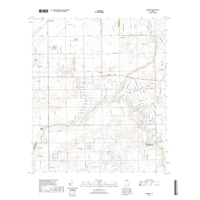
2018 Map of Hildreth
USGS Topo · Published 2018About this map
Ichetucknee Springs and the headwaters of the Ichetucknee River anchor the northern landscape of this region where Suwannee, Columbia, and Gilchrist counties meet. The survey reveals a terrain defined by groundwater interactions, featuring numerous karst-related water bodies such as Sampson Lake, Tussel Pond, and Clear Pond. Transportation patterns revolve around established rural routes like Old Bellamy Rd and SW Old Spanish Rd, which suggest the deep historic roots of the transit corridors through north-central Florida. Small rural centers and aviation sites, including Beachville and the Thompson Airfield, are interspersed with family and community landmarks like Ichetucknee Cem and Hunts Cem. To the south, the Santa Fe River winds toward Sandy Point, serving as a natural boundary in a landscape where forestry and agriculture have long shaped the local economy.
Find a feature on this map
177 named features on this map. Tap any name to fly to it.
Don’t see what you’re looking for? This feature index may not catch every label — zoom into the map to look around manually.
Map Details
Editions of this 2018 Hildreth Map
This is the sole edition of this map. No revisions or reprints were ever made.
Other maps of this area

1954 · Gainesville
USGS Topo · 1:250,000

1954 · Valdosta
USGS Topo · 1:250,000

1958 · Valdosta
USGS Topo · 1:250,000

1958 · Gainesville
USGS Topo · 1:250,000

1959 · Valdosta
USGS Topo · 1:250,000

1959 · Gainesville
USGS Topo · 1:250,000

1963 · Columbia
USGS Topo · 1:24,000

1968 · Branford
USGS Topo · 1:24,000

1968 · Hatchbend
USGS Topo · 1:24,000
1968 · Hildreth
USGS Topo · 1:24,000