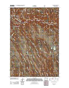
2011 Map of Hilgard
USGS Topo · Published 2011About this map
The Grande Ronde River carves a central path through this section of Union County, dictating the development of the corridor where the settlements of Hilgard and Perry are located. This early 21st-century topography shows how the river and its numerous canyon tributaries, such as Blacksmith Canyon and Peach Canyon, shaped the infrastructure for modern transit routes. While the river valley hosts the primary hubs of activity, the surrounding uplands toward Mahogany Mountain remain relatively undeveloped, dotted only by landmarks like Strober Ranch and several springs. To the southeast, the landscape transitions into a cluster of water features including Morgan Lake, Twin Lake, and Hunter Lake, with the engineering of the Morgan Lake Dam noted. Genealogists and local historians will find the Hilgard Cemetery situated just north of the river, serving as a permanent anchor for the families who settled this rugged terrain.
Find a feature on this map
41 named features on this map. Tap any name to fly to it.
Don’t see what you’re looking for? This feature index may not catch every label — zoom into the map to look around manually.
Map Details
Editions of this 2011 Hilgard Map
This is the sole edition of this map. No revisions or reprints were ever made.
Other maps of this area

1953 · Pendleton
USGS Topo · 1:250,000

1956 · Pendleton
USGS Topo · 1:250,000

1963 · La Grande SE
USGS Topo · 1:24,000

1963 · Hilgard
USGS Topo · 1:24,000

1963 · Summerville
USGS Topo · 1:24,000

1964 · Huron
USGS Topo · 1:24,000

1964 · Drumhill Ridge
USGS Topo · 1:24,000

1964 · Kamela SE
USGS Topo · 1:24,000
1965 · Glass Hill
USGS Topo · 1:24,000

1965 · Little Beaver Creek
USGS Topo · 1:24,000